Walking Minute Map: promote walking in in your area
For many destinations, walking is a great alternative to driving a car, taking a bus or cycling. However, it can be a challenge to convince residents or visitors of this. The Walking Minute Map (also called Walking Time Map) helps. This visual map illustrates the number of walking minutes and distance between relevant destinations in your municipality or area at a quick glance, and so helps to encourage walking.
Get insight into walking distance between destinations at a glance
A Walking Minute Map is a map that visually displays the distance between key destinations in two ways:
- The number of minutes it takes to walk from one point to another
- The distance in metres between destinations
In this way, it gives a quick insight into the walking distance between destinations - which in reality is often less than expected.
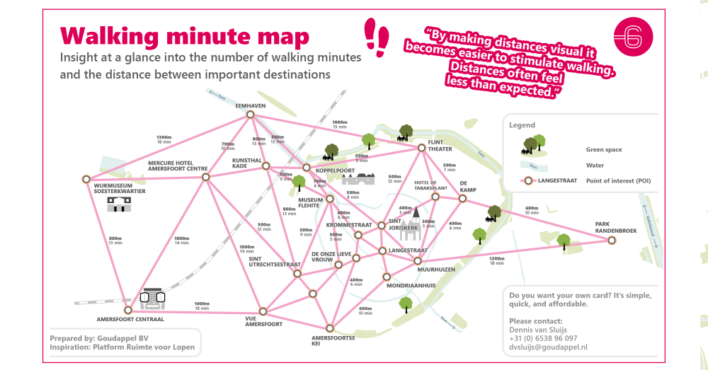
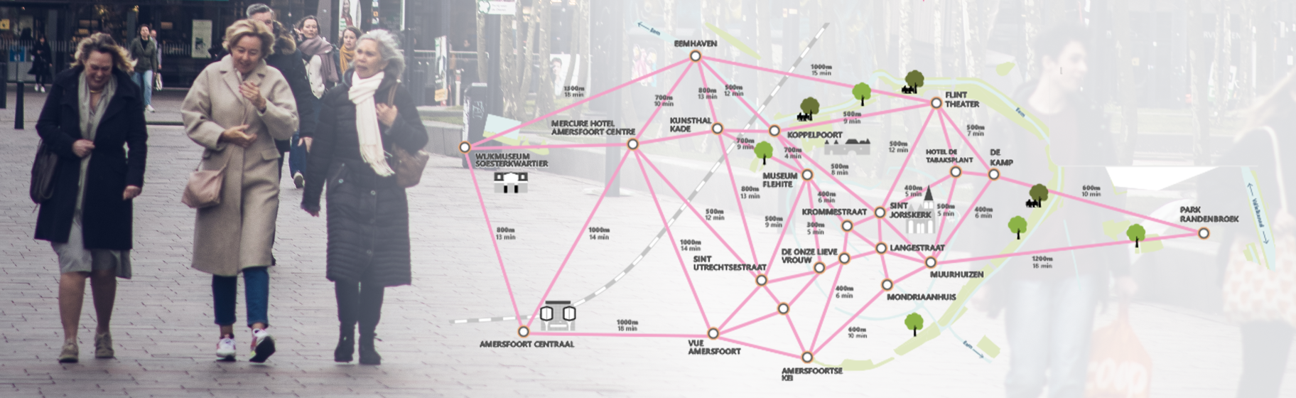
Example of a Walking Minute Map for the city of Amersfoort (NL)
Using the Walking Minute Map
Such a map is an effective tool for promoting walking in several contexts:
- For municipalities to stimulate citizens and visitors to walk between destinations (and to visualise policy plans)
- For tourism agencies to inform tourists and other visitors about the proximity of tourist destinations and facilities
- For transport operators to inform visitors about the proximity of relevant destinations from station areas and ov junctions
At Goudappel, we developed a quick and cost-effective method to create Walking Minute Maps in 3 steps.
Creating a Walking Minute Map in 3 steps
Follow-up advice
After its completion, we can also contribute ideas on how to use the Walking Minute Map and possible follow-up steps, such as developing a fully-fledged pedestrian network or understanding and influencing pedestrian flows in a particular area.
Inspired by Dutch platform Ruimte voor Lopen
The inspiration for our Walking Minute Map comes from the Dutch platform 'Ruimte voor Lopen', which aims to create space for walking in policy and public space in the Netherlands. Goudappel joined this platform in 2022.
Why you should choose for a Walking Minute Map from Goudappel
- Our method for creating Walking Minute Maps is fast and affordable because we use the possibilities of artificial intelligence (AI).
- We can create Walking Minute Maps for any location in the world, taking into account specific needs and the local circumstances.
- From our knowledge and experience on walking, we can not only make the Walking Minute Maps, we can also advise you on which input is most suitable.
- We are also happy to help you with other walking-related questions - we have in-house knowledge of all aspects of walking: from model-based analysis and simulation of pedestrian movements to setting priorities for pedestrians in policy, design and traffic regulations.
- Because we have different international partnerships, we use real-life insights in the further improvement of the Walking Minute Maps.